
(8 pm. – promoted by ek hornbeck)
Those of you that read this regular series know that I am from Hackett, Arkansas, just a mile or so from the Oklahoma border, and just about 10 miles south of the Arkansas River. It was a rural sort of place that did not particularly appreciate education, and just zoom onto my previous posts to understand a bit about it.
Tonight I am going to cover something a little different. Rather than recollections as a very small child, I shall fast forward to when the former Mrs. Translator were married and living in Fayetteville, Arkansas. When time permitted, we were quite the outdoor types, backpacking, rafting, spelunking, and just all around outdoor and nature enthusiasts.
Our mutual love of the out of doors was a real bonding element in our relationship, and even after the boys were born we did not stop going out of doors, but obviously we could not backpack with infants. We just modified how we enjoyed going until they got old enough to carry their own backpacks.
Here is sort of a map of Arkansas. The region of interest is in the extreme northwest part.
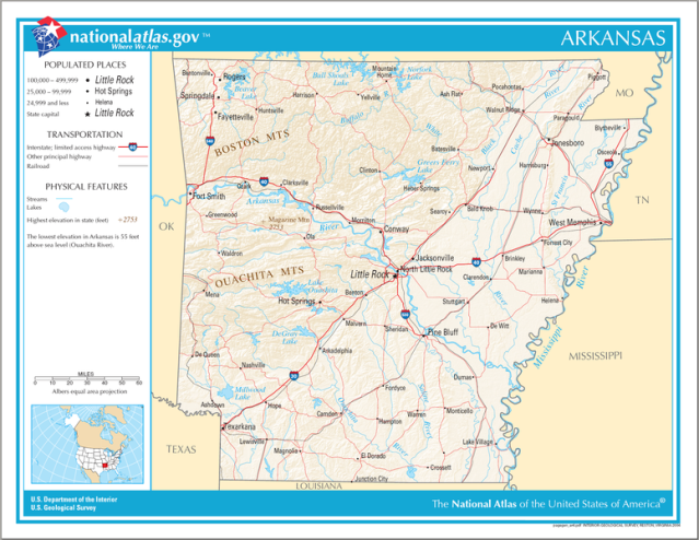
Find Fayetteville, just north of “BOSTON MOUNTAINS”. The region of which we have interest is just to the west of Fayetteville to around 60 miles to the east. The Boston Mountains are part of the Ozark Mountain range, and these are quite majestic. These are very old hills, much older than the Rockies but not as old as the Appalachians. The Boston Mountain subdivision is the most rugged. Geologists estimate that the Ozarks were thrust up around 1.4 to 1.3 billions of years ago.
I really wish that I had the personal photographs that the former Mrs. Translator and I took during our trips, but those are with her and I have no way to get them for tomorrow. I am sure that she would allow me to go through them and scan the ones important to me, but that is for another time. The pictures that I shall supply are from the internet, and some are quite copyright protected, so there will be quite a few links tonight.
Most of our adventures were on or near to The Buffalo National River, and a few other on or around the Illinois River. The Buffalo is to the east, and the Illinois to the west of Fayetteville. Before we had enough money to get our own gear, we rented it from the university. That was a very neat student service. We finally accumulated enough funds to get quality outdoor gear, but being able to rent different items and try them out was actually quite helpful.
Here is a map of the Buffalo River watershed. Please concentrate on the extreme left side, lower just to the east of where Highway 16 and Highway 21 intersect.
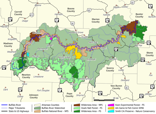
Not shown on the map is the tiny settlement called Fallsville. There use to be a store there, but it shuttered long ago. Now, I have not been there in decades, so it might be growing again, but I doubt it. About a mile and a half to the east of Fallsville is a very nondescript cattle guard that connects the highway with a logging road maintained by the US Forest Service. That goes down to the river, and there is plenty of good parking just up from the river.
In the days before the children, we would load up our backpacks and cross the river at Dixon Ford, following an old logging road. The logging road was on the western edge of the wilderness area and we could easily spend five or six days there without seeing anyone else.
We would often camp during spring break because the weather was still cool (sometimes very cold) so ticks and mosquitoes were not a problem. One spring we crossed Dixon Ford after taking off our hiking boots and socks, the water being about knee deep. After we made camp the first night, it started raining off and on and rained almost the entire time we were up on the mountain. Finally it stopped raining and we decided to get back to the car and get home before it started raining again.
When we got back to Dixon Ford it was a raging torrent! The knee deep, slow water was now at least ten feet deep and the 20 feet or so of wading was now way over 100. There was no way that we could have crossed there and lived. We had to hike, through some difficult terrain, upriver until we came to the three tributaries of the river, crossing them one at a time. Even then, we were up to our chests in water, but it was moving slowly enough that we were able to pass.
The former Mrs. Translator had a little dog named Cuddles, a cockapoo and very sweet, who always camped with us. Since we had our hands full holding our backpacks over our heads, I tied a rope around her collar and then around my waist and she swam across, being swept downstream to the extent of the rope. It took us at least an extra four hours go cross the river in this manner. Fortunately, there was kind of rough trail once we got across the creeks, so we made it back to the car OK. It took days to get our gear and boots dried once we got home!
We had a tradition of taking steaks, foil wrapped potatoes and corn, and beer to leave in the cooler in the car to have for a feast the night before we were going to leave the next morning. One trip we took with another couple and spent a few days on the mountain, and decided to leave early because it looked like rain, and we had learned from previous experience not to be on the wrong side of the river when that happened!
The four or us got back to the car around noon and decided to go ahead and camp on the good side of Dixon Ford that night and then go home in the morning. We sat up the tent in case of rain, then built a fire and cooked our feast. You can not imagine how good fresh food tastes after several days of summer sausage, hard rolls, and dried food! The cold beer was good, too! Thankfully, the rain held off until after we had finished eating and cleaning up, so we retired to the tent to keep dry.
It rained hard, and we began taking on water from runoff. It was a pretty miserable night, but we did not want to try driving the very steep and slick logging road out until the next morning. Just before daybreak we heard a terrific banging and clanging coming down the road. It turned out to be a group of kayakers, one of whom was our neighbor, also a university student. He told us, “Man, this GREAT! The water gets high enough to put in here only for or five times a year!” We hit a lot of rain in our trips.
We had planned a trip to cover the Buffalo River Trail, just recently opened, over Christmas break with a friend, Bruce. We needed two cars so the we could reprovision around the middle of the trail, and the plan was to park the second car there, drive back the the trailhead, pick up the first car, take it to trailend, then pick up the second one on the way out. This was to be around a ten day trip, and we planned for weeks, dried lots of food, and were ready to go.
A couple of days before we were to leave, Bruce backed out. The former Mrs. Translator talked about going anyway, but the second vehicle was so integral to the plan that we decided not to go. We were a bit aggravated at him at first, but as it turns out the weather deteriorated badly, with extreme cold and high winds, snow, sleet, and all the rest. We would probably have died if we had gone, so Bruce really did us a favor.
That bad spell was so cold that Bruce’s pipes froze and he finally found 21 burst places under his mobile home. That was a real mess. We also lived in a mobile home, but I had done a good job underpinning it and we let the faucets drip, so we had no freeze damage. A mobile home just up the street from us had severe damage, and it looked like it was sitting on top of an ice volcano before the thaw!
Another place that we liked to go was to Hemmed-in-Hollow. This is easily accessible be canoe and a short, easy hike. Hiking in is very rigorous if the water route is not taken to get close, about seven miles of difficult terrain. We did this once on a hot day, and we had a half grown tom cat with us, by the name of Adric. Adric began to get hyperthermia and was sort of yowling with his tounge sticking out. We finally found a puddle of water and immersed him in it, and he loved it! Until his demise he was never averse to water.
Here is a picture of Hemmed-in-Hollow. It is the tallest waterfall betwixt the Rockies and the Appalachians at 209 feet. One time when Eldest Son, Youngest Son, and Eldest Son’s best friend hiked in, two men were rappelling down the face of it. Youngest Son was quite impressed! Camping is not allowed there due to damage from high volume, but camping is allowed nearby.

If you go to Wikipedia and type in Hemmed-in-Hollow, there are links to some really nice copyrighted pictures. On our way out that trip, we found quite a few morel muchrooms that we took home and ate.
I am out of time for tonight, so will sign off now here. Please add any stories of your own in the comments.
My wrist is getting better in an accelerating fashion now. Whilst far from 100%, the improvement in the past three or four days is more than all of the time since the injury up to then, so I am sort or optimistic.
Warmest regards,
Doc, aka Dr. David W. Smith
Crossposted at
Docudharma, and
2 comments
Author
remembering distant memories?
Warmest regards,
Doc
Author
I very much appreciate it!
Warmest regards,
Doc