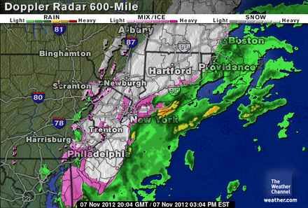
 With thousands still without electricity or even homes, the east coast from is being hammered with a northeaster that is bring rain, sleet, snow, plummeting temperatures, high winds and warnings of coastal flooding.
This was a storm with no name but another huge, impossible-to-miss footprint on the weather maps. Its white swirl was smaller than the hurricane’s but still looked ferocious, and it promised to be tenacious, with a chilly brew of rain and wet snow. Road crews feared it would bring annoying slush and, later on, treacherous ice to hard-luck places where debris from the hurricane was still being cleared away. [..]
Gov. Chris Christie warned that the northeaster could set back the recovery effort. He said that many people could lose electricity again.
“I can see us actually moving backwards,” Mr. Christie said at a news conference at a firehouse on Long Beach Island, the barrier island that suffered some of the heaviest damage in last week’s storm. Long Beach Island had been reopened to residents, but the governor said he was cutting off access again.
Mr. Christie said that 369,000 homes in the state were still without power, down from a peak of 2.76 million. Consolidated Edison said early Wednesday that about 79,000 customers were still in the dark, including 15,000 in Brooklyn, 13,000 in Queens and 41,000 in Westchester County.
Staten Island still has 3,205 “customers” without power and high winds are expected to take down more overhead lines. As with Sandy, coastal flooding is expected:
As happened with the Halloween hurricane, this nor’easter will begin doing its work here just as today’s afternoon tide comes in on Staten Island. High tide in The Narrows, measured at Fort Wadsworth, is at 1:24 p.m. That could mean wind-driven tidal surges 3 to 4 feet above normal high-tide levels in some areas – plenty to further damage already compromised low-lying coastal areas.
On Staten Island, those storm surges are expected to be around 2 feet above normal. [..]
According to (Brian) Edwards, (a meteorologist with AccuWeather), “A north to northeasterly wind means that the most significant coastal flooding will occur along the coast of Delaware, central to northern New Jersey, the western end of the north shore of Long Island, N.Y. and eastern Massachusetts.”
He said the worst of the coastal flooding and strongest winds are expected during two phases on Wednesday. The two times that are of utmost concern across the region are during high tide Wednesday afternoon and a second high tide late Wednesday night/early Thursday morning.
Evacuations have been ordered in New York and New Jersey:
After Sandy killed 40 people in New York City, Bloomberg ordered evacuations of low-lying, hard-hit areas such as the Rockaways section of Queens and the south shore of Staten Island. Residents of at least two coastal New Jersey towns were also told to leave.
While FEMA said it was working with state and local authorities and was “ready to deploy additional resources if needed to respond to the Nor’easter,” the [FEMA centers were closed today “due to the weather”]:
They fly into disaster areas, but flee from raindrops.
FEMA disaster recovery centers in Hurricane Sandy-ravaged sections of the city that were supposed to provide assistance to hurricane victims went MIA Wednesday morning, posting signs saying that they were closed due to the approaching Nor’easter.
The temporary shuttering of the facilities, which help victims register for disaster relief, as well as city food distribution centers come even as many of those still reeling from the monster storm were not told that they had to leave the battered areas.

3 comments
Author
I suppose it could always get worse.
That’s the frightening part.