
(4 pm. – promoted by ek hornbeck)
 The Great Recession of 2007-2009 triggered the Depression that we appear to be exiting this summer. And it was triggered by the collapse of the Great Turn of the Century Suburban Housing Bubble.
In coming out of the recent Depression, one driver of residential property values, the Cul de Sac, seems to be in conflict with a new driver: walkability. In October 2013, the Realtor(R) Magazine Online, of the National Association of Realtors, wrote, in Neighborhoods: More Walkable, More Desirable that:
Neighborhoods that boast greater walkability tend to have higher resale values in both residential and commercial properties, finds a recent study published in Real Estate Economics. In fact, a 2009 report by CEOs for Cities found that just a one-point increase in a city’s walk score could potentially increase homes’ values by $700 to $3,000.
And Ken Harney, writing for NewHomeSource.com, observes in that:
The core concept – connecting people with where they want to work, play and own a home by creating attractive neighborhood environments that make maximum use of existing transit infrastructure – fits many post-recession households’ needs, regardless of age. Older owners of suburban homes are downsizing into townhouses and condo units close to or in the central city, often in locations near transit lines. Younger buyers, fed up with long commutes to work, want to move to places where they can jump onto mass transit and get off the road.
Many of these buyers also have an eye on economics. For example, Bill Locke, a federal contracts consultant in northern Virginia, said that although owning a LEED-certified townhome near a Metro transit stop “is a really big deal” for himself and his wife, he sees the unit they recently purchased in the Old Town Commons development in Alexandria, Va., as a long-term investment that will grow in value “because it makes so much more sense” than competing, traditional subdivisions farther out from the city.
So, what does this mean for the sustainable transport and for the future of the deadly American Suburban Cul de Sac? Let’s have a chat about it, below the fold.
The Deadly Cul de Sac
First, lets start with the deadly status quo for suburban residental development, the Cul de Sac. Ironically, the Cul de Sac was first promoted in the 1920’s as a safer residential layout option. As observed in Reconsidering the Cul de Sac (pdf):
Ever since one of the first engineering studies on residential street safety was done in Los Angeles between 1951 and 1956, the Institute of Transportation Engineers has recommended hierarchical discontinuous street systems for residential neighborhoods. The study showed that the number of accidents was substantially higher in grid-based subdivisions, so ITE established engineering standards using cul-de-sacs.
Of course, this is based on accident figures, not risk of death or risk of injury figures. Most accidents when leaving the house from a Cul-de-Sac occur on a higher speed road that suburban developments rely on to connect to everywhere else. So the risk of injury and death is higher for the Cul-de-Sac pattern, despite a lower rate of accidents. As PedShed reported back in 2008, in a study comparing 24 Californian cities, “safe” cities, with severe/fatal accident rates 1/3 or more lower than the state average differed systematically from “unsafe” cities, with severe/fatal accident rates 1/3 or more higher than the state average:
- All of the “safe” cities were established before the ITE engineering standards were put into place, with an average intersection density of 106/mi2, a walk/bike/transit mode share of 16% and fatality rate of 3.2 per 100,000 people per year;
- while the “unsafe” cities, most established after 1950, had an average intersection density of 63/mi2, a walk/bike/transit mode share of 4% and fatality rate of 10.5 per 100,000 people per year.
And as reported by Tanya Snyder at Streetsblog from a 2011 forum on intelligent cities in Cul-de-Sacs Are Killing Us: Public Safety Lessons From Suburbia, Professor William Lucy of the University of Virginia has pointed out more ways that traffic accident data can be deceiving:
“They turn what should be a 100-yard walk into a two-mile drive, and they put more people in cars for more reasons than they should,” Lucy said. And because they get lulled into a sense of security, he said, parents don’t teach their kids about street safety and the “difference between street and sidewalk and driveway and yard.”
But the greatest danger to a young child, he said, is being backed over by a motor vehicle – usually driven by their own parents in their own driveway. Indeed, “backovers” account for 34 percent of “non-traffic” vehicular fatalities among children under 15 years old. (“Frontovers” account for another 30 percent, meaning that 64 percent of “non-traffic” vehicular fatalities still involve children being run over, according to KidsAndCars.org.)
Because these incidents occur on private property, they’re not considered “traffic” accidents and data is not collected by national traffic safety organizations. Meanwhile, Lucy said, squeamishness over openly reporting on the tragedy of a parent killing his or her own child with a car leads newspapers to bury news of backovers – missing a “teachable moment.”
So the Cul de Sac imply fatalities on the unsafe “stroads” that connect them to anywhere someone would wish to go, with the whole system having over three times the death toll per 100,000 people, according to the California study … while the Cul de Sac itself is less safe than it appears in the traffic accident figures, with many fatalities of those under 15 occurring at the driveway connecting to the Cul de Sac,
The Cul de Sac versus Walkability
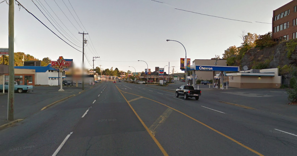 Now, Cul de Sac suburban developments imply a dependence on “stroads” to get almost anywhere. A “stroad” has been defined by the Urban Dictionary as:
Noun. Portmanteau of “street” and “road”: it describes a street, er, road, built for high speed, but with multiple access points. Excessive width is a common feature. A common feature in suburbia, especially along commercial strips. Unsafe at any speed, their extreme width and straightness paradoxically induces speeding. Somewhat more neutral than synonymous traffic sewer.
Stroads imply a higher death toll to getting anywhere to those who rely on them. But if the dependence on stroads are taken for granted, the appeal of living on a deadly Cul de Sac is quite rational, if one quite reasonably assumes that living along the stroad is even deadlier than using it every day. And if the death toll of the stroad is taken for granted as “normal”, and we turn our eyes away from many of the the children killed by cars in their own Cul de Sac neighborhoods, its relatively easy to maintain the social fiction of the “quiet, safe Cul de Sac neighborhood.”
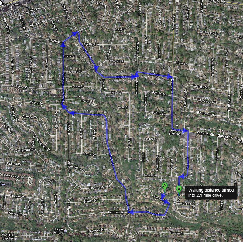
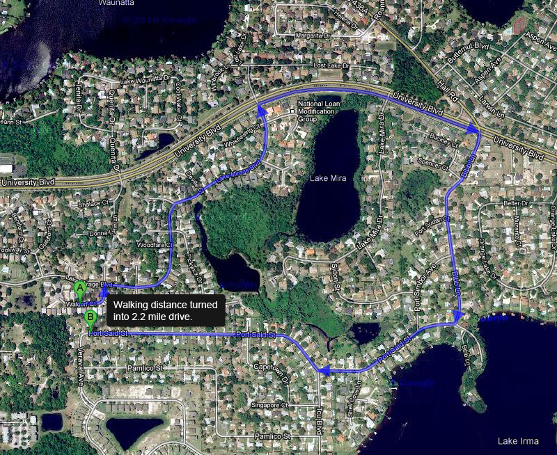
But Cul de Sacs have been criticized for more than the death toll associated with their supporting transport system. They also have been criticized for their negative impact on walkability. Chris Norstrom in has a number of illustrations of the extremes of the problem using overhead illustrations of houses within walking distance of each other being turned into multi-mile drives (click through for a number of additional examples):
The simplest way to “fix” this is with cross-connecting cycleway and sidewalk connectors that interconnect Cul de Sacs together. The challenge, of course, is that this is a system in which most people must rely on the car. The existing street layout makes getting somewhere useful on foot or by bike far more difficult than need be, which includes getting to a bus stop on the stroad where the bus must operate if it is to get anywhere. And therefore we can expect strong resistance to the idea of improving accessibility through a Cul de Sac road, given that most existing homeowners paid extra to be on a more secluded street.
And we can also expect pushback from property developers. After all, while safety was the selling point, a large part of the reason why the safety myth was being used to sell the Cul de Sac was the Cul de Sac allows property developers to offload costs onto the surrounding area. As mentioned in passing in Reconsidering the Cul de Sac (pdf), as if it was not as important to the adoption of Cul de Sac development as the original confusion about traffic safety:
The pattern is popular with developers not only because it sells well, but also because the infrastructure costs are significantly lower than for the traditional interconnected grid pattern, which can require up to fifty percent more
road construction.
The dramatic decrease in interconnections comes with a cost, however. Going back to the 2008 post from PedShed:
The key is this: The cost to operate a fire station generally is fixed. The size of the service area and the number of properties served per station don’t really affect operating cost. Therefore, the bigger the service area and the more properties that can be served, the more efficiently the fire department is using taxpayer money. If the fire department can serve more properties with fewer stations while meeting response time standards, it can save taxpayer money.
The study examined eight fire stations in the Charlotte area and found as street connectivity increased, the number of households served by each fire station increased as well. The least-connected service areas served 5,700 to 7,300 households; the most-connected service areas served 20,800 to 25,900 households. That means there are dramatic differences in the fiscal efficiency of individual fire stations. The stations in least-connected areas cost $586 to $740 per capita annually; the stations in most-connected areas cost $159 to $206 per capita annually.
Now, we normally regulate the Cul de Sac to ensure that the fire trucks can get in … it is the need to get fire trucks and fire engines (as well, in more northerly climes, snow removal equipment) that results in the typical “lollipop” look, with the turn-about at the end of the Cul de Sac often 100ft or more in diameter. But we don’t normally charge the developer for the extra capital cost over the expected life of the development for the extra emergency service stations required to serve a residential development designed around single points of connection to a stroad and a meandering Loop Street and Cul de Sac street layout.
New “Secondary Street Acceptance Requirements” in Virginia limit the ability of developers to gain Virginia DOT maintenance on Cul de Sac streets. And Charlotte, N.C., Portland, Ore., and Austin, Texas (NPR report) have largely banned new Cul de Sac development.
However, there is still a market premium for being on a Cul de Sac, even as there is a growing market premium for being a Walkable neighborhood. And so there are a growing number of ideas being developed how one could have a “walkable Cul de Sac”.
The Walkable Cul de Sac: Our Suburban Future … or an Oxymoron?
 I have already quoted from the background to the Cul de Sac from Southworth and Ben-Joseph’s “Reconsidering the Cul de Sac”, but the purpose of the piece is to introduce design patterns which retain some of the features that people value about Cul de Sacs, without sacrificing walkability in the process. There are two basic approaches to this: connecting the Cul de Sac for pedestrians (and, one hopes, cyclists as well), and disconnecting the Grid for vehicles.
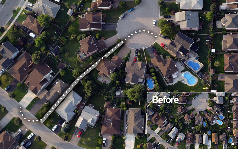
The first approach is shown in the retrofit to the right. The problem, here, is that the offering people the opportunity to get from one part of a Cul de Sac to another will provoke opposition from some residents who do not want their dead-end-street turned into a through street, even for pedestrian and cycling transport … while at the same time, this is likely to invite very little determined support, because the ability to walk to other houses in the neighborhood is a lot less important for “Walkability” than the ability to walk to work, to school, to shop, out to dinner, to the library, and etc.
Contrast that to a cycleway with sidewalks as sketched below. It cuts across from where one secondary through road begins to turn into a stroad, to run into the back side of a Target department store. And there are small connectors linking onto it Loop streets of previously single-access developments.
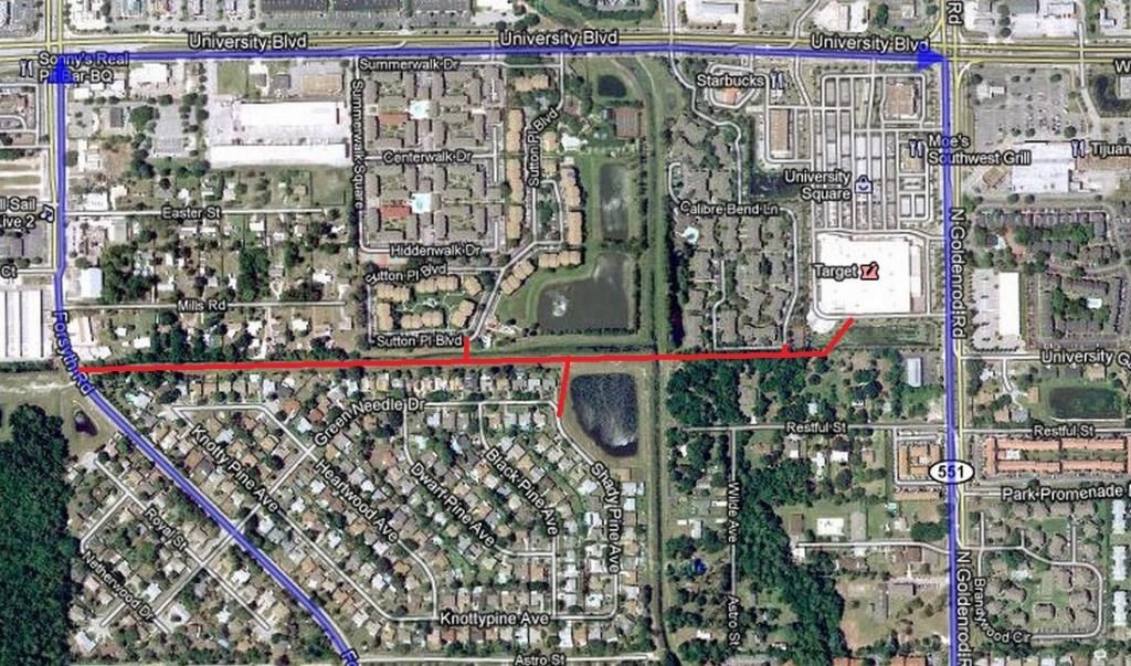
So this makes the Target store a “walkable” destination for the residents of “Shady Pine Avenue” and of “Sutton Point Boulevard” (setting aside whether it should be legal to call a secondary Loop street a “boulevard”). If there is a bus route connecting to the Target or on North Goldenrod, a main through road, it also makes makes the bus stop a walkable stop for those residences.
And given that non-motor-vehicle through route, there is now a reason for people on the two single street developments in the block at the top left to want to extend a walking and bike path from the dead-end sides of their streets.
As a side effect it is also possible to go from “Shady Pine Avenue” to “Sutton Point Boulevard” without having to drive on University Blvd, but the walking access between residences in two adjoining developments would not be the driving factor in gaining acceptance of the retrofit.
The Loop Without the Lollipop: Grid-Based Approaches.
But this is not the only kind of retrofit we need to do. We also need to retrofit what are presently big box stores, strip malls and enclosed malls surrounded by massive parking lots into mixed use residential / commercial / professional cores. That retrofit does not start with an existing Cul de Sac development. It is targeting the residential space that has the most to gain from the walkability benefits of the grid. And it is targeting the residential space where we gain the most from higher density development, in areas that do not have legacy anti-density restrictions such as excessive lot setbacks and two floor height restrictions, making it possible to establish a denser pattern, such as multiple stacked townhouses per lot.
 This is one approach that could be taken to providing secondary streets without through traffic for this kind of retrofit. The side streets are one shared car and bike lane going one way, with an exclusive bike lane going the other way, and of course with sidewalks on both sides of the street. There is no through car traffic because a car can’t drive through. This is enforced with the diagonal cross sidewalk protected by ballards that block any cars that would be interesting in violating the one way traffic sign and attempting to drive through the wrong way down the next street.
For pedestrians, the 2×2 block is a the same as a normal street grid, with the addition of a catty-corner crossing in the middle of the block that is protected from car traffic. And cyclists can pedal through the grid as well. Indeed, the two central paths form a target for a “cycle boulevard”, with a mix of calmed car traffic and exclusive cycle lanes.
And for developers, the cost of street access should be substantially lower than for a conventional two-way street grid.
This may be an attractive mix of traffic exposure for a mixed use area, with roughly half of the lots fronting onto the two way main through streets and the other half fronting onto one-way single block. However, if there is more demand for walkable residences than demand for mixed use street level professional and commercial space, then there may also be a peripheral residential retrofit blocks where there is more demand for side-street lots than is satisfied by this 1:1 ratio of main street and side street facing lots.
 However, one can increase the ratio of side streets by … doing the same thing again, in this 4×4 lot layout. Note how the car access is precisely the confusing welter of loops and T-intersections so prized in Cul de Sac developments … but for pedestrians and cyclists, its still a simple 4×4 grid.
And now the central cyclist through routes are even more appealing for cycle boulevards, with four blocks of transit between each main street crossing. If the transport stops are on the intersections of main through streets and cycle boulevards, then the street crossing infrastructure can be shared between cyclists crossing the street and pedestrians crossing between the two directions public transport directions of travel.
Conclusions and Conversations
OK, so these are some ideas for retrofitting the demand for side-streets that are sheltered from traffic with the demand for greater walkability than most of our current suburbs offer.
Which of these ideas do you find most appealing? And what other ideas have you come across, or come up with, for squaring this same circle?
As always, the Sunday Train does not finish with the end of the essay … that is just the prelude to the conversation. So feel free to introduce any issue involving sustainable energy and transport into the mix.
3 comments
Author
The French “Cul de Sac” sounds better in a real estate listing, but.
and recently moved to a more traditional neighborhood that was developed in the ate 50’s with the traditional grid street design. At the cul de sac home, we were an easy walk to the bus stop for the commute into Manhattan but to get to the faster train necessitated a drive, either someone dropping then picking up or leaving the car in a park & ride lot. Now, the train station is a 10 minute walk cutting the commute by an hour and more exercise.